Still undecided but have been debating whether I’m going to pick up a new GPS unit or Trent Waterway Charts at all.
Trying to limit gear purchases to things I can reuse after the trip. Most of the Trent Waterway is quite narrow and channel markers should be easy to follow without Charts or GPS. They do provide water depth as well but not worried about that in a kayak with no engine to hit rocks with.
Full set of Nautical Maps has 10+ different maps, I have to worry about storing them all and keeping them dry, they aren’t little compact things that you can just put in your pocket. Once I finish the trip I have no use for them anymore. I already have Georgian Bay charts and GPS in the boat, that’s where I usually go anyway, don’t think I will be kayaking the Trent a second time and think it’s a waste.
Do I need another GPS device just for this trip? I already have GPS in the car and boat, too bad they aren’t portable enough to bring in a kayak.
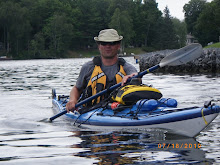
My Blackberry however, is small enough and I’m already bringing it along (waterproof case and 2 spare batteries+charger) it has full GPS and I will be in areas with full cellular coverage, doesn’t show water depth but I’m not concerned with that. I can also use it to track progress and that was the primary reason I wanted GPS anyway. My Blackberry provides Lat/Lon coordinates and the new Google Map tracking application is pretty decent.
Still covered off from a safety perspective, I really only need to know direction to nearest land mass, my Blackberry can give me that if I need it. I also don’t care if I get lost, as long as safety isn’t an issue, that’s half the fun.
I’ve also been working out compass bearings on paper and will cross check with boat GPS when I can get to it, will see where I end up with that before I make a final decision.
skip to main |
skip to sidebar
Georgian Bay to Lake Ontario via Trent Severn Waterway
No comments:
Post a Comment